
After so many months deep in the tropics, we were avoiding going too far North because of the bad weather up there.
| CHART |
 | |
| Sketch Maps and Chartlets (not to be used for navigation!) © Copyright 1999-2000 Nigel Jones, MistWeb Technology | |
For many years I have heard stories about a mysterious green flash that can sometimes be seen just after the sun sets (or, apparently, just before it rises). I have read quite scientific-sounding explanations of this invloving atmospheric refraction, heard salty sea-dog tales and even seen some photos in a magazine once. I had never seen it and was just about ready to write the whole thing off as hog-wash: some huge hoax, some maritime equivalent of an urban legend.
At sunset (1947 local time, 2147 UTC) on the 27th May 2000 in position 35°N 40°W, Nicky and I both clearly saw a luminous green blob which appeared on the horizon where the last of the sun had just disappeared. It began about half a second after the upper limb of the sun dipped and lasted about a further half-second. There was no cloud in the sky or on that part of horizon at all at the time.
We were to see this twice more during the trip (14th June and 25th June). The trick seems to be an horizon absolutely clear of cloud. Even near the centre of the Azores High in mid-summer this is rare. The colour is clearly green, but not a saturated shade. Some of the perception of green could just be as an optical reaction to having stared at an orange-red sun for the last few minutes, but it seemed more intense than that. The flare or flash was about one-quarter to one-third the width of the sun and perhaps one-eighth or one-tenth of its height.
 |
| A cargo ship passing us safely one afternoon. |
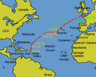
By the 29th June all our sources of weather information on HF and LF radio were warning of quite severe weather fronts north of about 38° North. We were at 35½° N 37° W with about 450 miles to go. Horta in Faial, the Azores, is at 38½° North but the general advice for this trip is to continue north, perhaps to 40° North to keep the wind and drop down into Horta from the north in the last day or so. Each of these degrees of latitude represents 60 miles on the surface.
We had had an easy an uneventful passage so far and, with the intention of keeping it so, we decided not to go any further north until this weather had cleared or until we absolutely had to to make the harbour.
We were at 35° 42' N with 250 miles to go on the 31st May when the southern end of the worst of the weather passed across us. We had winds between 20 and 30 knots (Force 6 to 7) all day with a wild sea and well reefed sails . We made 120 miles during that 24 hours.
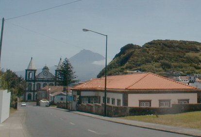 |
| The neighbouring island of Pico as seen from the beautiful island of Faial. |
By the next afternoon we were motorsailing into a gentle head-wind straight towards our Horta waypoint. We had tried tacking but in the end motorsailed for the last 24 hours to make harbour.
The island group of the Azores, in Mid-Atlantic, is a principality of Portugal. They have their own flag which they would like you (on pain of a heavy fine if you don't!) to fly below the Portuguese one for courtesy. Faial is one of the islands in the group and Horta is the name of the main town and its associated harbour and marina in Faial. I mention all this because we heard many people confused in their use of these place-names.
We found, in some contrast to mainland Portugal, that the people of Horta were friendly and helpful. Their use English is not as widespread as it was in Portugal, but this was not a problem as our tiny knowledge of their language, a bit of Spanish and a dictionary was all that was needed.
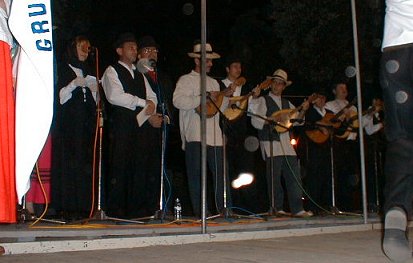 |
| The local residents of Horta celebrating something or other with some outdoor music and dancing. |
MAYS (Mid-Atlantic Yacht Services), the local chandlery was very capably run by Duncan and Ruth Sweet and their staff. We didn't have much to sort out, but they solved the few little problems we had on the boat during our stay. They can be contacted by e-mail at mays@mail.telepac.pt but be careful: reading and replying to e-mails appeared as a priced item on our bill when we left.
We only stayed a week because by this time we found that really the wanderlust was used up, the urge to explore had been satiated and our intention to get home was starting to turn into something closer to homesickness. The weather in the Atlantic was a mess. Those fronts had ripped the Azores high to bits and what was left seemed to be drifting aimlessly to the west, against the way the jet-stream and the Gulf Stream should have been driving it.
During the week we re-stocked the boat with perishables, water and fuel, had some excellent meals and snacks in the town and painted our boat-name on the sea-wall.
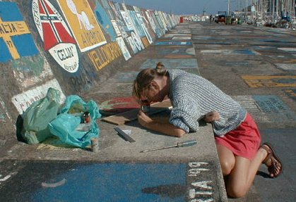 |
| It is a tradition that visiting yachts should paint their boat-name onto the pier in Horta marina. Here Nicky gets to work. |
We visited the famous Peter's Bar (Cafe Sport) but were unimpressed by him, the prices or the noisy and often drunken clientele. It's become a bit of a rowdy tourist trap. There was a little bar on the marina pier too and we were surprised by the degree of drunkenness among the English-speaking visitors here as well. Most of the pier was a-twinkle with broken glass from the bottles and glasses they must throw around in the wee, small hours. This made our normal habit of walking around barefoot a bit hazardous. People who had lost control both of their legs and their ability to focus could be seen trying to climb off the pontoons onto their boats routinely each afternoon.
By the 10th June we were ready to leave and, after a last visit to the fuel dock we took Rusalka out of the harbour under sail with a gentle 10 knots of wind behind her.
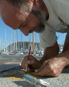 |
| Nigel adds his contribution to the masterpiece. The local DIY shop does a good trade in little tins of gloss paint! |
Two days later we were reaching along, clear of the islands, with a very unusual south-east wind brought about by a severe gale over a thousand miles away at 60° North. We heard tell of a low-pressure system off Lisbon which was, again unusually, heading north towards Biscay. This was due to cross our path at some time in the future but we were busy watching the whales and dolphins which are so common around the islands. One very large animal - perhaps 45 feet (15 m) long - crossed our bow only yards away and then sounded. As it flicked its huge tail below us to dive for the depths a great, smooth dome of disturbed water appeared beside us.
Around this time, in addition to the Radio France International forecasts for the North Atlantic on 15.300 MHz at 1140 UTC, we began to be able to take down the BBC Shipping forecasts on 198 kHz at 2348 and 0435 UTC. We were seeing winds up to 26 knots (Force 6) and getting forecasts between Force 4 and 7 through the 16th June.
On the 17th June the RFI forecast for Charcot - our sea area at the time - was, "Variable, anticyclonic Force 4 to 6, perhaps Force 6 to Gale Force 8 in the West of the area..." This was the first time I have sat at sea and received a gale warning for the very area I'm in, with nothing I could do about it except wait for it to arrive. The Lisbon low was nearly upon us.
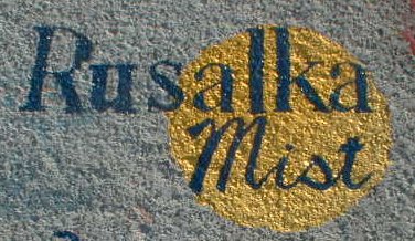 |
| Finished! Look out for it if you're there - let us know if it's still legible! |
The next day we were passed by what must have been 40 or 50 fishing boats heading south-east in a huge convoy. We guessed that this was the Spanish and/or the Portuguese deep-sea fleet heading for home, perhaps because of the same forecast. We watched them pass for several hours, ahead and behind us, sometimes within 50 yards. Meanwhile we nodded and dipped and splashed our way north-east toward an increasingly black, bleak and lonely-looking horizon. We tried a few calls to them on VHF Channel 16 but no-one replied. The sea had lost that amazing blue we had come to take for granted: even though it was still 3000 m (10,000 feet) deep, it was a dirty-looking grey-green colour. We still had 800 miles to go.
